California Coastal Trail Signage Map
Map of Signage Reaches from Coastwalk’s SCC Grant 08-084.
This map and it’s contents are not currently available to the public.
Legend
 Northermost point of reach
 Southernmost point of reach
 Geodata exists but not in database
Click each point for additional information.
About this Map
Green markers identify the Northernmost point of a reach list. Clicking on the marker will display the Reach name, the associated SPID, the County, the number of miles and the beginning and longitude/latitude for the reach. Yellow markers identify the southernmost end point for a reach. Datapoints designated with a purple marker show where Coastwalk staff and volunteers have collected additional information that does not fall under an approved or installed reach.
Reach names: derive from the Northermost start point common place name to the Southermost end points common place name. (e.g. Salmon Creek Beach North to Bodega Head).
Signage Plan IDs or SPID numbers begin with one of the 15 California coastal counties (01=Del Norte … 15=San Diego) followed by the californiacoastaltrail.info map section number for that county, and then by the start date of the field collection.
EXAMPLE:
SPID Number 04-12-092810 refers to:
county number – 04 (Sonoma)
Sonoma Section Map number: 12
see map here: http://goo.gl/7oaYpJ
and a start date of: September 28th, 2010 or 09.28.10
CCT Signage Database
Coastwalk’s CCT signage database contains a listing for each designated Reach as well as information for each individual sign location including descriptions of the location, where the sign is to be installed, photos of the recommended site and any notations pertaining to that sign location. This information is hosted in a online database that can be found by following the link below:
* This database has a restricted number of users and requires a Coastwalk generated ID and password, please contact the office for any additional information.
CCT Signage Documents
Summary Signage Plan for each Reach are contained in files located in Coastwalk’s Google Apps for Nonprofits guest account. These files include summary information and maps for each signage reach. To access this information:
* an account with Coastwalk’s Google Apps for Nonprofits is needed for access to these files.
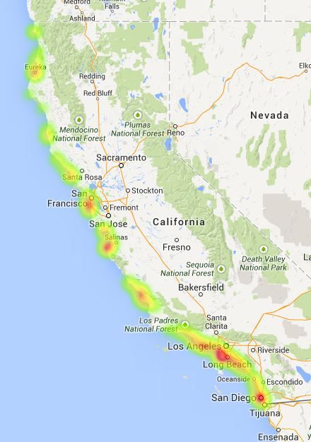
CCT Signage Heat Map
This map is used by Coastwalk in meetings and training’s to show current gaps in the trail and signage.
The red areas identify the highest concentration of reaches and data collected by Coastwalk.
This map should only be used as one tool for identifying trail gaps as it does not currently show all reach points or identified Coastal Trails.